Planivy.CZ - Caves
In this section we prepared basic description of our caves with links on maps and animated polygons. Situation of caves is illustrated on orientation map.
Most of the caves, which we're doing research in are found in a location of an underground part of a creek Bila Voda near a village Holstejn in the north of Moravian Karst (Hradsky zleb Glenn as a part of Ostrovsky zleb Glenn).
Most of the caves, which we're doing research in are found in a location of an underground part of a creek Bila Voda near a village Holstejn in the north of Moravian Karst (Hradsky zleb Glenn as a part of Ostrovsky zleb Glenn).
Ostrovsky zleb Glenn is the karst valley at the eastern margin of the northern part of the Moravian Karst between Skalni mlyn and Holstejn village. It consists of several individual parts: semi-blind Holstejnske Valley, Hradsky zleb Glenn and Ostrovsky zleb Glenn. Creeks of Bila voda, Lopac, Krasovsky potok and Vilemovicke vody Waters took part in the formation of the valley.
Predominantly, there're vertical cave systems with labyrinths of passages on many levels and with huge flood tunnel.The denivelation is 70 - 130 m. For ascent and descent into the caves we're using rigid ladders made of steel or SRT eventually. The temperature inside of the caves is usually 6°C (43 °F) during whole year.
Amaterska cave
| map | polygon |
The Stara Amaterska (Old Amateur) Cave was discovered from the Cigansky doline on January 18, 1969 by the members of the Planivy Group belonging to the Speleological Club Brno. The Nova Amaterska Cave was then discovered on August 16, 1969 from the Povodnovy (Flood) Sump at the end of the Povodnova (Flood) Passage at the end of the Stara Amaterska Cave. The discoverers visited only a part of this giant system. The exploration behind the sump continued only next year, but it was interrupted by the catastrophic flood on August 29, 1970. Milan Slechta and Marko Zahradnicek died. Since 1971, the exploration has been carried out, in 1972 even during continuous decrease of water level in the sump. During those operations, the place with the closest distance from the wall of the Pusty zleb Glenn was surveyed. The artificial gallery was excavated in 1973 solving the problem of security and easy access to the Nova Amaterska Cave. Detailed explorations and survey have been carried out since 1974. The main interest was focused to the connection of the cave with the Macocha Abbys. The connection was realized by divers in 1975 when 420 m long Predmacossky Sump with depths of 20 m was crawled through. After this solution, only the problem to connect the cave with the system of the Sloupsko-Sosuvske Caves has rested. Access from mentioned caves was unsuccessful. The exploration was after directed from the Nova Amaterska Cave upstream the Sloupsky Corridor. In 1989, divers discovered another 1,200 m of passages and passed through the 3rd sump. The next sump has not yet been conquered. After the control of the cave was obtained by caver, the exploration of chimneys and detailed survey have been carried out especially in the Sloupsky Corridor and in the Labyrinth of Milan Slechta.
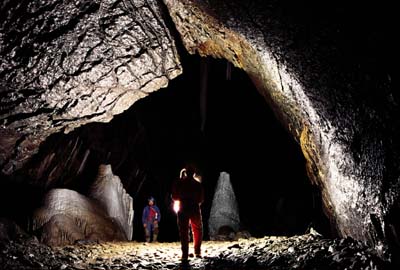 Nova Amaterska cave - U Dvou Velkych (At Two Big) chamber (photo by Z. Motycka) |
The Nova Amaterska Cave is characterised by extensive tunnel-shaped passages with the variable amount of fluvial deposits and screes. The passages change sometimes into the domed spaces. Such passages represent the higher cave level at about +20 m above lower cave level, which are genetically older. The altitude difference of both cave levels diminishes towards the ponors. The resurgence part close to the Macocha Abyss and Punkevni Caves is influenced by the blocked outflow . The middle part of the system, where the confluence of both Punkva tributaries occur, the cave is rather maze-like with numerous cave levels. Numerous passages are flooded here during water highstands and the hydrological situation is rather complicated.
The Nova Amaterska Cave can be entered through 100 m long artificial tunnel leading from the meander of the Konsky Spad into the Javorova (Maple) Passage, which continues into the Zapadni Macossky (Western Macocha) Corridor. Here, slightly to the right, the largest hall of the cave - the Absolon´s Dome - is situated. From the Dome we can continue through passage and Bahnita (Muddy) Lakes up to the active course of the Punkva River. Our downstream course will lead us to the Predmacossky Sump, which separated the Amaterska Cave from the Macocha Abyss. Upstream, the riverbed continues up to the Zadni (Back) Lake fed by the Punkva River. From this place, the Vychodni macossky (Eastern Macocha) Corridor continues by the Stupnovitá (Step-like) Passage up to the Roztoka Dome in the higher level. The Východní and Západní macošský Corridors join together in the Roztoka Dome forming 900 m long Macossky (Macocha) Corridor, which continues to the NNE. The Corridor is richly decorated by variable forms of speleothems. At its end on the left side, there are three entrances into the Bludiste (Labyrinth) of Milan Slechta. The Labyrinth represents the confluence of the Sloupsky potok and Bila voda Creeks during floods. Speleothem decoration is not so rich here due to often damages during floods. The most interesting place of the Bludiste is located around the Riceny (Collapsed) Dome. Rozlehla (Spacious) Passage represents the continuation of the Macossky Corridor. It is the greatest passage in the Moravian Karst. At U homole Dome, the passage divides into the Sloupsky Corridor and Belovodska (Bila voda) Branch. The latter, leading to the Holstejn village, continues further by collapsed Soubezna (Parallel) Passage up to the Dlouhe (Long) Lake. To cross the lake, boat must be used. The active riverbed of the Bila voda Creek will be reached behind the Lake. The Chodba samoty (Passage of loneliness) leads upstream through the largest dome of the Cave (Katedrala J.Slechty - Cathedral of J.Slechta) up to inflow Povodnovy (Flood) Sump of the Stara Amaterska Cave. From the U homole Dome, the Sloupsky Corridor leads through four lakes to the Cerny (Black) Dome with the labyrinth of passages and active stream of the Sloupsky potok Creek. The continuation is through narrow passages and Turbina (the narrowest place at the courase of the Sloupsky potok Creek,) up to the back part of the Sloupsky Corridor. It is spacious passage richly decorated by speleothems. The active riverbed will be followed along its left side terminating at inflow sumps of the Sloupsky potok Creek from lower parts of the Sloupsko-SoSuvske Caves.
Spiralka cave
| map | polygon |
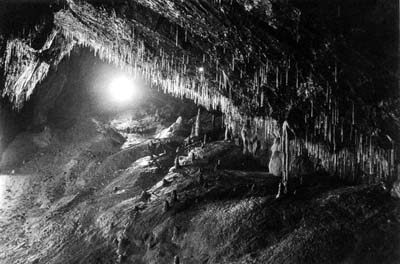 Decoration in upper level of Modry (Blue) chimney |
The entrance, 20 m deep shaft (constructed of concrete cylindrical segments) leads to fissure-shaped small passage by which the roof of 40 m deep Ustredni (Central) Shaft can be reached. The connecting passage with the Pikova dama Cave (Spojnice Passage) is situated in the half of the shaft. The shaft bottom is formed by scree cone descending to the level of Jezirko (Lake) - i.e. to the entrance to the sump between the Pikova dama and Spiralka Caves. On the other side, the cone descends to the beginning of the Tunelova (Tunnel) Passage. The complex labyrinth of passages around the Patecni (Friday) Shaft and Fetanka Shaft is situated above the Jezirko. The bottom of the Fetanka Shaft is the level of sump lake between the Spiralka and 13C Caves. The Tunelova Passage continues up to the Odtokovy (Outflow) Sump ant the end of flood riverbed of the Bila voda Creek. Varhany (Organs), the largest speleothem form of the Spiralka Cave, is situated above the sump. Balvanita (Boulder) Passage with the Rotunda continues upstream of the Bila voda Creek. The Pritokovy (Inflow) Sump is situated about 10 m lower to the S. There, the new connection of the cave towards the Nova Rasovna Cave was found with the help of pumping. The first two domed spaces - Discodom and U prepadu (At overflow) Dome - has an ascending character. Their bottoms are covered by large limestone blocks. Narrow descending and meandering passages continues further to the Dome U 12 prasat (Dome at 12 pigs), where terminates by the Belgicky (Belgian) Sump. High and narrow Passage of Potapecu (Divers) continues behind the sump up to the Macossky Sump of the Nova Rasovna Cave. The total length of the Spiralka cave is about 1,800 m. The cave is equipped by fix steel ladders.
Pikova Dama cave
| map | polygon |
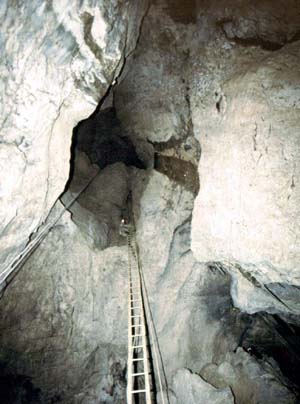 Entrance shaft - Studna (the Well) |
13C cave
| map | polygon |
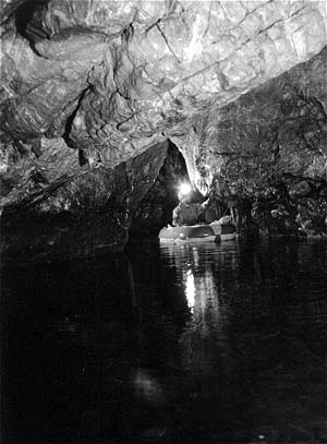 Shipping on the Bila Voda (White Water) creek |
Planivy cave
| map |
 View from Planivy cave |